
WINDY ANEMOMETER for Android
Windy Anemometer application use external Navis wireless sensors to measure wind speed, direction and air temperature.
Compatible sensors: WINDY MARINE, WINDY B/S, WINDY B/SD.
If you don't have your sensors yet, please select "GET SENSOR" in application's settings menu.
VIEWS IN APPLICATION
Main view - Anemometer
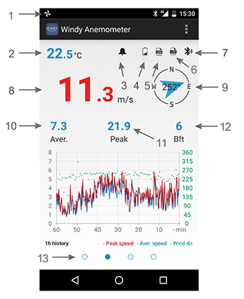
- 1 - Application activity icon indicates application's activity.
- 2 - Air temperature - data from sensor's built-in temperature sensor.
- 3 - Alarm icon shows up when wind speed alarm is turned on and set.
- 4 - Low battery icon shows up when battery in sensor is low and needs replacement.
- 5 - Log icon indicates data logging status (enabled, disabled, error).
- 6 - Live icon flashes every time data is send to Navis LIVEDATA web interface.
- 7 - Signal icon every time data is received from sensor, icon flashes.
- 8 - Current speed in units set in settings. When wind speed exceeds alarm value, numbers become red and flashes.
- 9 - Wind rose - wind direction graphical and numerical display.
- 10 - Average speed in last 1, 3 or 10 minutes (adjustable in settings).
- 11 - Peak speed - maximum wind speed. Can be reset with long/double tap on peak speed value or label.
- 12 - Speed in Bft (Beaufort) scale.
- 13 - Indicates which graph is displayed - wind 10min, 1h, 12h or temperature 24h.
Main view - Marine
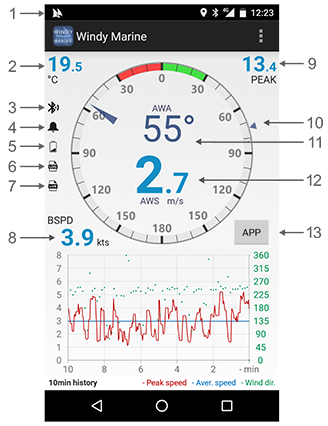
- 1 - Application activity icon indicates application's activity.
- 2 - Air temperature - data from sensor's built-in temperature sensor.
- 3 - Signal icon - every time data is received from sensor, icon flashes.
- 4 - Alarm icon shows up when wind speed alarm is turned on and set.
- 5 - Low battery icon shows up when battery in sensor is low and needs replacement.
- 6 - Log icon indicates data logging status (enabled, disabled, error).
- 7 - Live icon flashes every time data is send to Navis LIVEDATA web interface.
- 8 - GPS boat speed - boat speed measured with smartphone's built-in GPS device.
- 9 - Peak wind speed - maximum wind speed. Can be reset with long/double tap on peak speed value or label.
- 10 - True Wind Direction* - displays true wind direction
- 11 - Apparent/true wind - wind direction graphical and numerical display.
- 12 - Current wind speed in units set in settings. When wind speed exceeds alarm value, numbers become red and flashes.
- 13 - Apparent/true wind - button for switching between apparent and true wind.
Gauge mode - long tap/press on gauge to change gauge mode - normal (0 - 180°) or macro (0 - 60°).
Full screen graph view
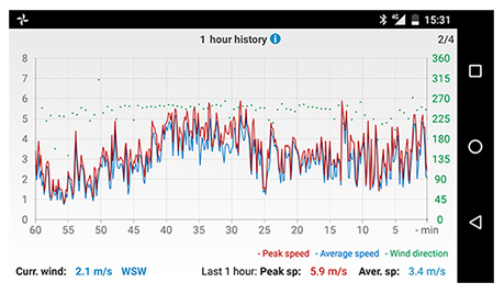
Icon  shows more information about graph.
Curr. wind - current wind speed and direction
Peak sp - peak speed in last 10min, 1h, 6h or 24h depending on selected graph
Aver. sp - average speed in last 10min, 1h, 6h or 24h depending on selected graph
FUNCTIONS
How to use Windy software?
Windy Anemometer software uses external wireless sensors to measure wind speed, direction and air temperature.
If you don't have your sensors yet, please click Get sensors in main menu.
How to connect sensor with your smartphone?
Each sensor has its own address, which is written on label at the bottom of the sensor.
Navigate to Settings in Main menu and select your sensor type. In case of using separate wind speed and direction sensors, select WS/WD option. For combined sensor (measuring wind speed and direction with one sensor) select WSD option.
Write your sensors addresses into fields (WS - wind speed sensor, WD - wind direction sensor, WSD - combined wind speed and direction sensor) or select Nearby sensors for automatic scan.
Navigation in Windy application
For navigating through graphs, use right to left swipe gesture to display next or left to right to display previous graph. In main view, tap desired graph for full screen graph view. For navigation from full screen back to main view, use system back button.
In full screen graph mode, you can tap graph title or [info icon] to see more graph information.
How to reset peak wind speed?
Tap and hold peak value on main screen for 2 seconds or double tap it and peak wind speed will be reset.
How to mute alarm sound when alarm is active?
When alarm is active, current wind speed is colored red and it is flashing. To mute alarm tap and hold for 2 seconds or double tap flashing current wind speed numbers or alarm icon.
Flashing will continue until alarm is turned off or wind speed drops below alarm limit.
LOCAL DATA LOGGING
Windy Anemometer is able to log wind data and temperature to device local memory in three intervals.
WSD - Sensor type (WS - wind speed, WD - wind direction, WSD - wind speed & direction)
16 - Sensor address
01_07_2016 - Starting date of data logging [dd_mm_yyyy]
09_16_20 - Starting time of data logging [hh_MM_ss]
WS - Average wind speed in logging interval
WSm - Peak wind speed in logging interval
WSt - Average temperature in logging interval
WD - Average wind direction in logging interval
n/a - No data: usually, when sensor/-s are not in range or data can't be calculated.
nW - No wind: only with wind direction data; In cases, when wind speed is 0.0, wind direction can't be correctly detected.
HINT #1 - to store log files at least one sensor address must be set different than 0.
| Logging interval | New line in file | New file | Max. file length |
|---|---|---|---|
| 10 seconds | Every full 10 s | Every day at 0:00 | 8.640 lines [400 KB] |
| 1 minute | Every full 1 min | Every first day in month at 0:00 | 44.640 lines [2,00 MB] |
| 10 minutes | Every full 10 min | Every first day in month at 0:00 | 4.464 lines [208 KB] |
Icons
| Description | |
|---|---|
| Data logging in device internal memory is enabled | |
| Flashes every time data is send to Navis LIVEDATA web interface |
Log file name explanation
WSD16_01_07_2016_09_16_20.txtWSD - Sensor type (WS - wind speed, WD - wind direction, WSD - wind speed & direction)
16 - Sensor address
01_07_2016 - Starting date of data logging [dd_mm_yyyy]
09_16_20 - Starting time of data logging [hh_MM_ss]
Log content example
                    	Windy Anemometer v1.1.9

                        NAVIS Elektronika

                        -----

                        Logging Interval:10s

                        WS [m/s], WSt [°C], WD [deg]

                        dd/mm/yyyy, hh:mm:ss, WS, WSm, WSt, WD

                        01/07/2016, 09:16:20, 1.2, 1.7, n/a, 112

                        01/07/2016, 09:16:30, 0.0, 0.0, 24.3, nW

                        01/07/2016, 09:16:40, 0.4, 0.6, 24.2, 98
WS - Average wind speed in logging interval
WSm - Peak wind speed in logging interval
WSt - Average temperature in logging interval
WD - Average wind direction in logging interval
n/a - No data: usually, when sensor/-s are not in range or data can't be calculated.
nW - No wind: only with wind direction data; In cases, when wind speed is 0.0, wind direction can't be correctly detected.
Data logging - troubleshooting
HINT #1 - to store log files at least one sensor address must be set different than 0.
SETTINGS
GENERAL
Main view - switch between different main view modes
SENSORS
Find sensor - use for automatic scan of nearby sensors
DATA UNITS
wind speed unit - [m/s, km/h, kt, mph]
boat speed unit - [m/s, km/h, kt, mph] *Marine view only
temperature unit - [°C, °F]
AVERAGING PERIOD
Aver. speed - averaging period for average speed showed in main view [1 min, 3 min, 10 min] *Anemometer view only
ALARM
Alarm switch - enable/disable alarm
Alarm value - alarm value/limit in speed unit set in wind speed unit section
CALIBRATION
WS cal. factor - wind speed calibration factor [-15% ... +15%]
WD offset - wind direction offset [-180° ... + 180°]
Temperature cal. - temperature calibration [-2.0°C ... +2.0°C or -3.6°F ... +3.6°F]
DATA LOGGING
Data logging switch - enable/disable logging function
Logging interval - select between three logging intervals
Log destination - path to the log files on device's memory (typically '/Documents/WindyAnemometer')
LIVE DATA
Send data - enable/disable sending data to Navis LIVEDATA web interface
S/N - enter serial number generated on Navis LIVEDATA web interface
APPLICATION
Display Auto Off
Checked - display will turn off after some time
Unchecked - display will never turn off
Restore defaults - reset all values in application, except sensors addresses
PLEASE NOTE
- - Application requires device with Android 6.0 (or newer) and Bluetooth 4.0 BLE.
- - Application will increase battery consumption of smart device because of active Bluetooth communication.
- - Application will use Wi-Fi or cellular for sending data to Navis LIVEDATA web interface. Additional charges my apply depending on user Wi-Fi/cellular data plan.
- - In case of simultanous use of wifi/bluetooth functions, data loss from bluetooth sensor is posibble to occur.
- - Application developers will not be held responsible for any data loss due to unstable or unreliable internet connection
- - Application developers does not accept responsibility for any problems which may arise from applications other than those the product was designed for.
- - Any liability for direct or indirect damage caused by application failure is excluded.
CONTACT DEVELOPER
In case of any kind of problems with Windy Anemometer software or critics/improvement ideas, please write to atomski.software@gmail.com